


Minamisoma City, Fukushima and LAND INSIGHT Inc. — Pioneering a shift to push-type support for farmland maintenance in mountainous areas
— In line with national policy reforms, satellite and terrain data with AI will visualize farmland that may qualify for payments and support municipal outreach to communities —
Penguin Labs LLC (Head office: Chuo-ku, Tokyo; Co-CEO: Shimpei Akatsuka; "Penguin Labs"), Minamisoma City, Fukushima (Mayor: Kazuo Monma), and LAND INSIGHT Inc. (Head office: Minamisoma, Fukushima; President and CEO: Takahiro Endo; "LAND INSIGHT") are jointly launching a demonstration project for push-type support, in which municipalities proactively promote use of direct payment programs for mountainous and other areas. Using satellite and terrain data with AI, the project visualizes farmland that may qualify for payments and launches an integrated initiative in which the city supports mountainous communities from program outreach and consensus-building through application.
Background: More than half of eligible farmland remains unused
In June 2026, the Ministry of Agriculture, Forestry and Fisheries published basic concepts for a new rice paddy policy, calling for a shift from waiting for community applications to a push-type approach for direct payments in mountainous areas, and promoting digital technology to streamline selection of eligible farmland. This demonstration implements that policy shift on the ground.
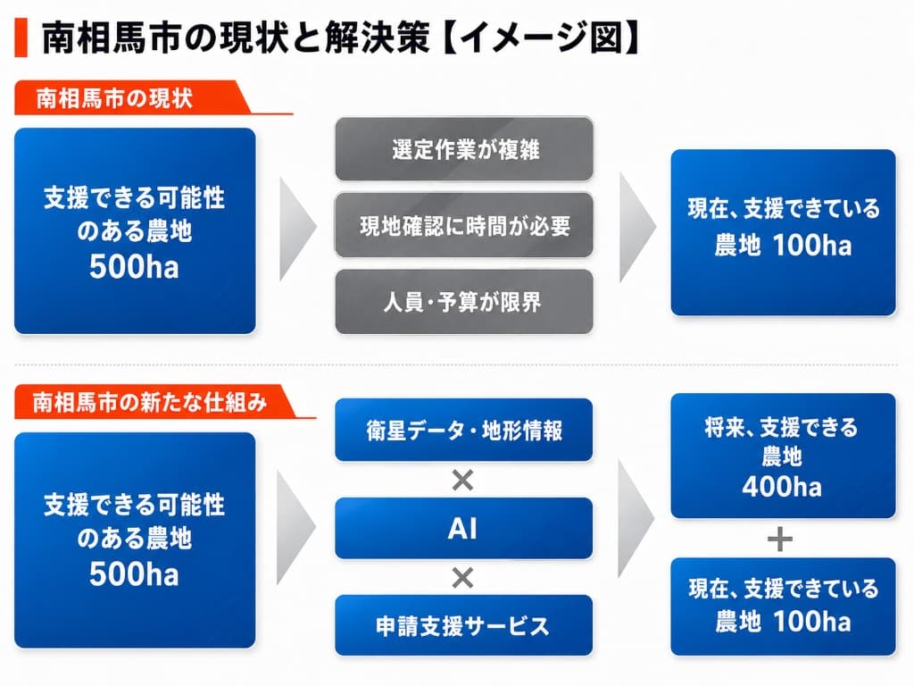
The direct payment program for mountainous and other areas supports communities that conclude agreements to continue agricultural production where conditions are disadvantageous compared with flatland. Total payments in FY2024 reached about ¥53.1 billion. Yet MAFF estimates that only about half of eligible steep-slope fields (132,000 ha implemented out of 266,000 ha eligible) and about 30% of gentle-slope fields (151,000 ha implemented out of 523,000 ha eligible) are covered (MAFF, "Basic concepts and mechanisms for a new rice paddy policy," June 2026). Combined, only 283,000 ha out of 789,000 ha potentially eligible (about 36%) are covered—meaning the program has not reached more than 60% of eligible farmland. Against a backdrop of aging, labor shortages, and the burden of application procedures, mechanisms to protect farmland are not reaching many of the communities that need them.
In this policy review, the government has signaled a shift to a push-type approach, including plans for regional agricultural administration bureaus nationwide to begin outreach to municipalities with low program uptake from FY2026. For municipalities to act proactively, they must first know which farmland may qualify and which communities are being left behind—work that is difficult to do manually.
Demonstration scope: Find, reach, and apply—with data and AI
The project builds an information base for push-type municipal outreach using satellite and terrain data with AI, and validates it on the ground across about 12,000 parcels in the former Ishiki and Kamimano areas of Minamisoma City.
- Visualizing candidate farmland ― DEM and satellite data are analyzed to extract parcel-level fields that may meet slope and other eligibility requirements, including steep, gentle, and extra-steep slope categories and contiguous steep-slope blocks, displayed on aerial imagery
- Gap visualization ― By overlaying currently supported farmland, the system identifies areas where the program is not being used despite eligibility, helping municipalities prioritize outreach
- Estimated payment amounts ― For candidate parcels, annual and five-year cumulative estimated payments are calculated (reference values based on prefectural unit prices for the 6th program period) for use in briefings with communities and farmers
- Exploring efficiency in applications and related work (including generative AI) ― Together with the city, the partners will explore how extracted parcel information can streamline agreement applications and related administrative tasks
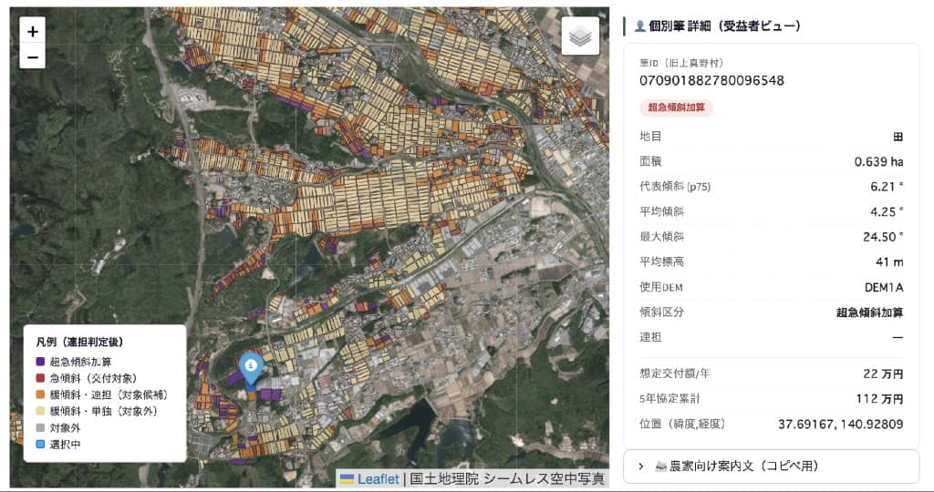
※ Judgments and payment estimates from this system are automated projections based on public data. Final eligibility is determined by the municipality after on-site confirmation and other review.
Roles of the three partners
| Organization | Role |
|---|---|
| Minamisoma City | Providing the demonstration field and related data; validating and operating outreach to communities |
| Penguin Labs | Developing the farmland visualization system using satellite, terrain data, and AI; building slope classification, contiguous-block detection, and payment estimation logic; developing AI-assisted application document generation (using TWINZ Plus, patent pending) |
| LAND INSIGHT | Hearing surveys with municipalities and communities using the program; reviewing compliance with program requirements |
Next steps
After validating effectiveness in Minamisoma City, the partners aim to expand to municipalities nationwide with mountainous farmland. LAND INSIGHT has deployed its field-survey efficiency service "Hojo DX," born in Minamisoma, to more than 120 municipalities. Penguin Labs will generalize the analytics and AI foundation built in this project as part of its geospatial intelligence platform TWINZ Plus (patent pending), expanding beyond direct payments for mountainous areas to other agricultural administration and farmland evaluation needs domestically and internationally. This demonstration goes beyond streamlining field surveys to broaden the scope of agricultural administration support toward proactively promoting program uptake, pioneering the national push-type shift from the field.
Company overview
About Penguin Labs LLC
Founded March 2024. A deep-tech company developing products that integrate satellite, weather, soil, and terrain data with AI for agriculture and geospatial intelligence. Its core product TWINZ Plus achieves soil moisture estimation accuracy exceeding public satellite products. Centered on R&D and licensing of analytics engines and AI models, it serves municipalities, financial institutions, and agricultural companies. In July 2026, it won first place in Theme 1 ("Technology development contributing to solving problems at production sites") of "NEDO Challenge, Satellite Data — Updating agriculture, forestry, and fisheries with satellite data!" hosted by METI and NEDO, and the Grand Prize of the Satellite Data Utilization Award 2025-2026, platinum-sponsored by Norinchukin Bank in partnership with the same contest.
URL: https://penguin-labs.com/en
About LAND INSIGHT Inc.
Founded April 2022; subsidiary of INCLUSIVE Holdings Inc., which focuses on regional value creation and industrial efficiency. A GovTech company developing services using satellite data, based in Minamisoma. Its "Hojo DX" service streamlines agricultural administration field surveys and is used by more than 120 municipalities (as of February 2026). Received the Minister of Agriculture, Forestry and Fisheries Award at the 7th Space Development and Utilization Awards in February 2026.
URL: https://landinsight.space/
Inquiries
Penguin Labs LLC — Public relations
Web form: https://penguin-labs.com/contact/